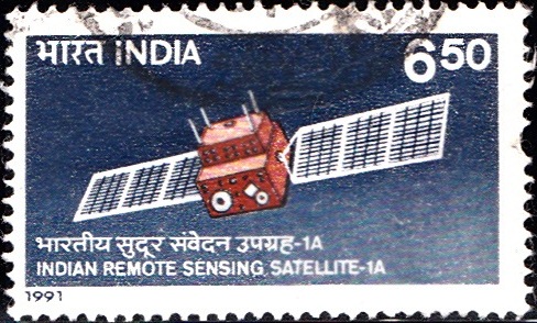
Indian Remote Sensing Satellite 1991
A commemorative postage stamp on the Completion of 3 years in Orbit of IRS–1A, first remote sensing mission undertaken by ISRO (Indian Space Research Organization) :
Issued by India
Issued on Mar 18, 1991
Issued for : Deptt. of Posts is privileged to issue a special stamp on the completion of three years in orbit of IRS-1A.
Description of Design : The stamp and the First Day Cover are based on art works provided by ISRO. The stamp depicts IRS-1A in orbit. The First Day Cover depicts INSAT Master Control Facility at Hasan. Cancellation is designed by Ms. Nenu Gupta.
Type : Stamp, Postal Used
Colour : Two Colour
Denomination : 650 Paise
Overall size : 4.06 x 2.41 cms.
Printing size : 3.70 x 2.05 cms.
Perforation : 13 x 13
Paper : Indigenous Un W/M Gravure Coated Adhesive Stamp Paper
Number printed : 10,00,000
Number per issue sheet : 45
Printing Process : Photogravure
Printed : India Security Press
About :
- The first Indian Remote Sensing Satellite, IRS–1A, completes three years of successful operation on March 17, 1991. The state-of-the-art remote sensing satellite is playing a vital role in the management of country’s natural resources. India is the fifth country in the world to have its own operational remote sensing satellite. IRS-1A is an advanced as any contemporary remote sensing satellite such as the US LANDSAT and the French SPOT satellite.
- IRS-1A has become the mainstay of the National Natural Resources Management System (NNRMS) for effectively managing the natural resources of the country. It has so far covered the entire country about fifty times and provided more than three lakh imageries. Several national remote sensing application missions like land-use/land cover mapping for agro-climatic planning, wasteland mapping, integrated land and water resources study for combating drought, flood mapping and management, crop acreage and yield estimation, watershed prioritisation and command area development, soil salinity/alkaline mapping, forest mapping, etc. are being carried out using IRS-1A data. In addition to the five Regional Remote Sensing Service Centres (RRSSCs) set up by the Department of Space in different regions of the country, many State Governments have set up remote sensing application centres providing necessary facilities for analysis of IRS-1A data and retrieval of various types of information.
- The 975 kg satellite carries two advanced cameras, Linear Imaging Self-scanning Sensors, LISS – I and LISS – II, with spatial resolutions of 72.5 m and 36.25 m respectively. LISS – I provides a swath of 148 km and the two LISS – II cameras provide a composite swath of 145 km. The satellite, built with totally indigenous capability, incorporates most advanced technologies including driven deployable sun-tracking solar panels, three-axis body stabilisation using dry turned gyros, reaction wheels, scanning sensors and reaction control system, high bit rate image transmission, automatic payload operation, etc.
- IRS-1A, is controlled through a set of complex on-orbit manoeuvres to maintain it in the specified 904 km polar sun-synchronous orbit. The satellite returns to its original orbit trace every 22 days enabling repeated collection of data at the same place and at the same local time. The Spacecraft Control Centre in Bangalore, along with ground stations at Lucknow and Mauritius, regularly track, monitor and control the spacecraft. The National Remote Sensing Agency (NRSA), Hyderabad receives the data from IRS-1A in S-band and X-band and the data is disseminated to more than 500 users in the country.
- Text : Courtesy ISRO Bangalore.
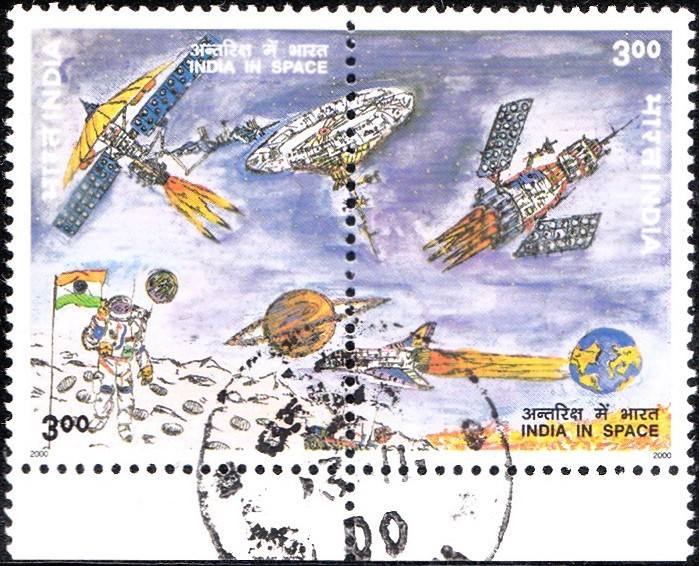
[…] has established two main space systems – the Indian National Satellite (INSAT) system and Indian Remote Sensing Satellite (IRS) system, which have become important elements of national infrastructure. INSAT is one of […]